All Products

Liberia (Operation World)
Largest Religion: Ethnoreligionist Number People Groups: 39 Number Languages: 31 Official Language: English For more information go to Liberia on the Operation World website. The above link opens in a new tab.

Liberia (Prayercast)
Government: Presidential Republic Major People Groups: Kpelle, Bassa, Grebo, Gio, Mano GDP Per Capita: $1,500 Literacy Rate: 48.3% Unreached: 11.4% Population: 5,214,030 Religions:...
Liberia (WorldBank)
NOTE: The most recent year's information is shown below. Click on the year to see all years for this indicator. COMMUNICATION2021 1,653,000 Mobile cellular subscriptions2021 34 Individuals using the...

Libya
For a more detailed listing click here Berbers have inhabited central north Africa since ancient times, but the region has been settled and ruled by Phoenicians, Greeks, Carthaginians, Persians, Egyptians, Greeks, Romans, and Vandals. In the the...
Libya (Joshua Project)
Progress Scale: Unreached Population: 7,459,000 Capital: Tripoli % Islam: 96.49 % Professing Christian: 2.58 % Evangelical: 0.18 Peoples Count: 53 In 10/40 Window:...

Libya (Operation World)
Largest Religion: Muslim Number People Groups: 31 Number Languages: 32 Official Language: Arabic For more information go to Libya on the Operation World website. The above link opens in a new tab.

Libya (Prayercast)
Government: In transition Major People Groups: Tripolitanian Arab, Cyrenaican Arab, Sanusi Bedouin, Arabized Berber, Sudanese Arab GDP Per Capita: $10,300 Literacy Rate: 91% Unreached:...
Libya (WorldBank)
NOTE: The most recent year's information is shown below. Click on the year to see all years for this indicator. COMMUNICATION2022 13,940,000 Mobile cellular subscriptions2014 18 Individuals using the...

Liechtenstein
For a more detailed listing click here The Principality of Liechtenstein was established within the Holy Roman Empire in 1719. Occupied by both French and Russian troops during the Napoleonic Wars, it became a sovereign state in 1806 and joined the...
Liechtenstein (Joshua Project)
Progress Scale: Superficially Reached Population: 40,000 Capital: Vaduz % Professing Christian: 77.10 % Evangelical: 0.56 Peoples Count: 9 In 10/40 Window: N Region:...
Liechtenstein (Operation World)
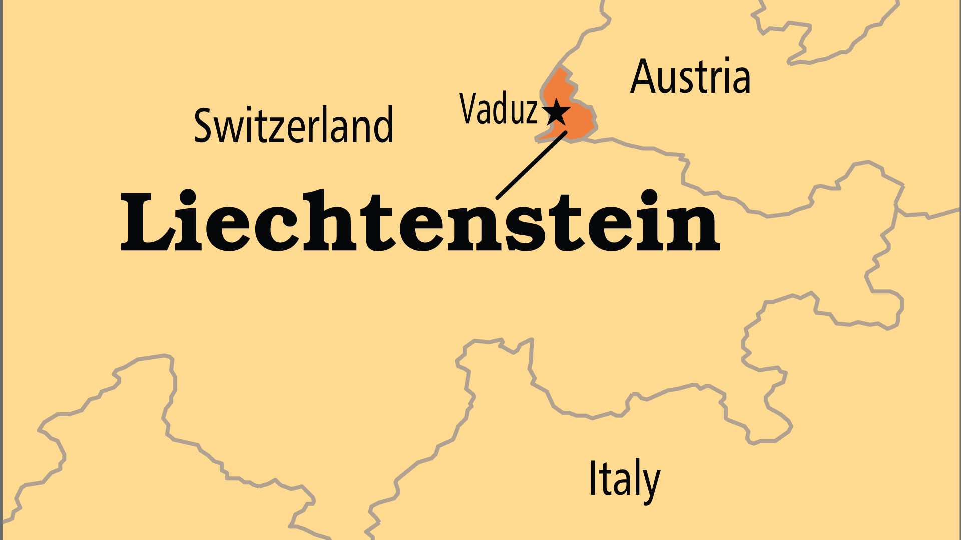
Largest Religion: Christian Number People Groups: 8 Number Languages: 4 Official Language: German, but the common tongue is Alemmanic, a divergent dialect of Standard German For more information go to Liechtenstein...

Liechtenstein (Prayercast)
Government: Constitutional Monarchy Major People Groups: German Swiss, Austrian, Walser, German (High German) GDP Per Capita: $139,100 Literacy Rate: 100% Unreached: 2.6% Population:...
Liechtenstein (WorldBank)
NOTE: The most recent year's information is shown below. Click on the year to see all years for this indicator. COMMUNICATION2022 49,662 Mobile cellular subscriptions2021 96 Individuals using the...
Life Expectancy Rates throughout the World
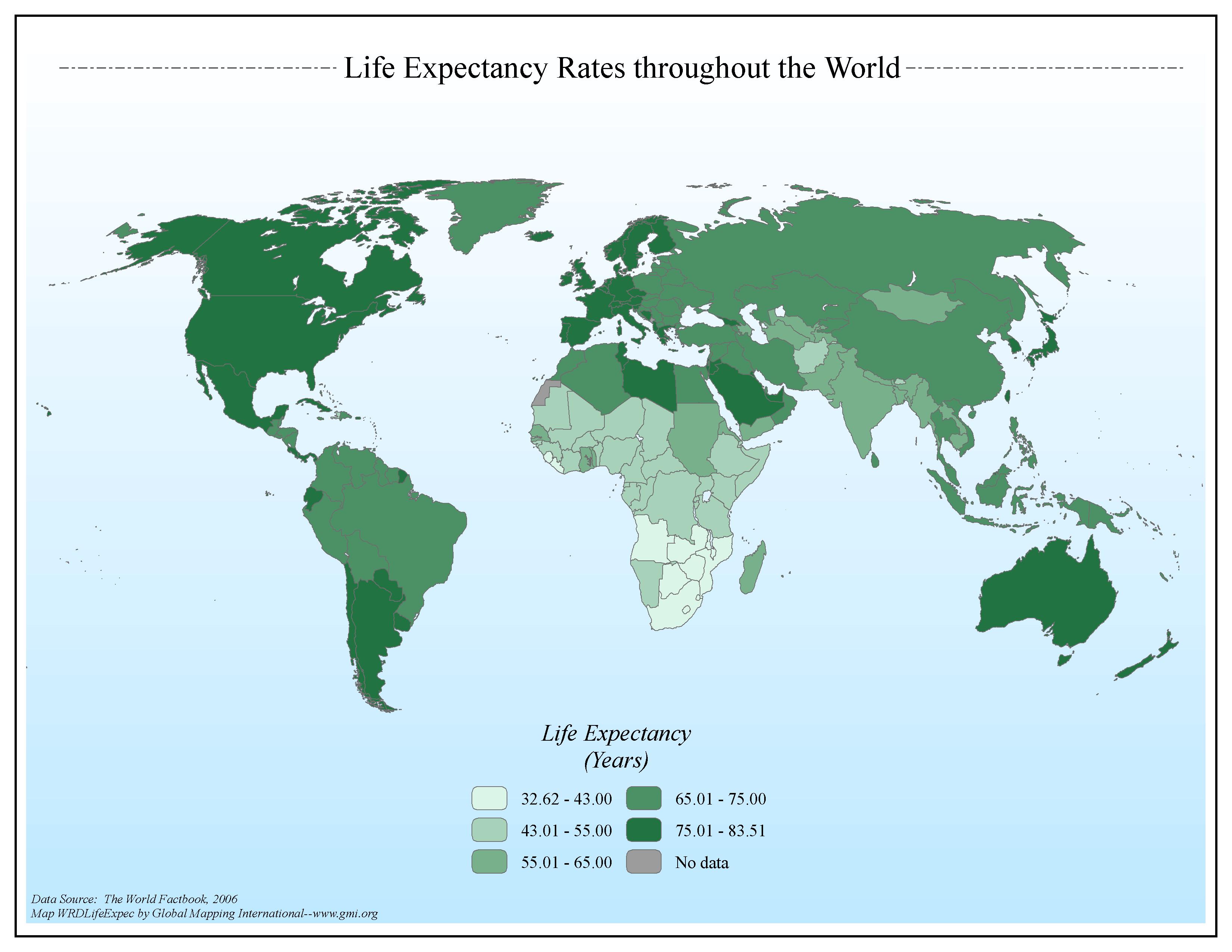
·Type: Maps ·Map Date: 2006 ·Data Source: The World Factbook, 2006 ·Producer: Global Mapping International ·Collection: Factbook (GMMS 2007) ·Size: 8½ x 11 inches, landscape ·Categories: Type...
Life of Jesus (Gospel of John) (Jesus Film)
And truly Jesus did many other signs in the presence of His disciples, which are not written in this book; but these are written that you may believe that Jesus is the Christ, the Son of God, and that believing you may have life in His name. -John...
Life of Jesus Series (Jesus Film)
MentorLink International and Jesus.net have partnered to develop this series of innovative discipleship tools specially designed to help users deepen their walk with Christ. This series delivers video clips from The Life of Jesus (The Gospel of...

Light the 10/40 Window: Strategic Towns
·Type: Maps ·Map Date: 2006 ·Data Source: Jesus Film Project, January 1999 ·Producer: Global Mapping International ·Collection: General World Maps (GMMS 2007) ·Size: 8½ x 11 inches, landscape...
Light the Window Video for Praying through the Window II
·Type: Video ·Date: 14 January 1999 ·Producer: CBN ·Collection: Videos ·Duration (H:M:S): 10:27:00 (approx) ·Resolution: 200x148 ·Categories: Topic :: Strategy Partners :: AD2000 Collection :: AD2000...
Light the Window Video for Praying through the Window IV
·Type: Video ·Date: 13 January 1999 ·Producer: CBN ·Collection: Videos ·Duration (H:M:S): 10:55:00 (approx) ·Resolution: 224x168 ·Categories: Topic :: Strategy Partners :: AD2000 Collection :: AD2000...
Listening to the Global Church: Key Insights from the Lausanne 4 Listening Process
Listening to the Global Church: Key Insights from the Lausanne 4 Listening Process with Eiko Takamizawa What does the global church have to say about the future of global mission?
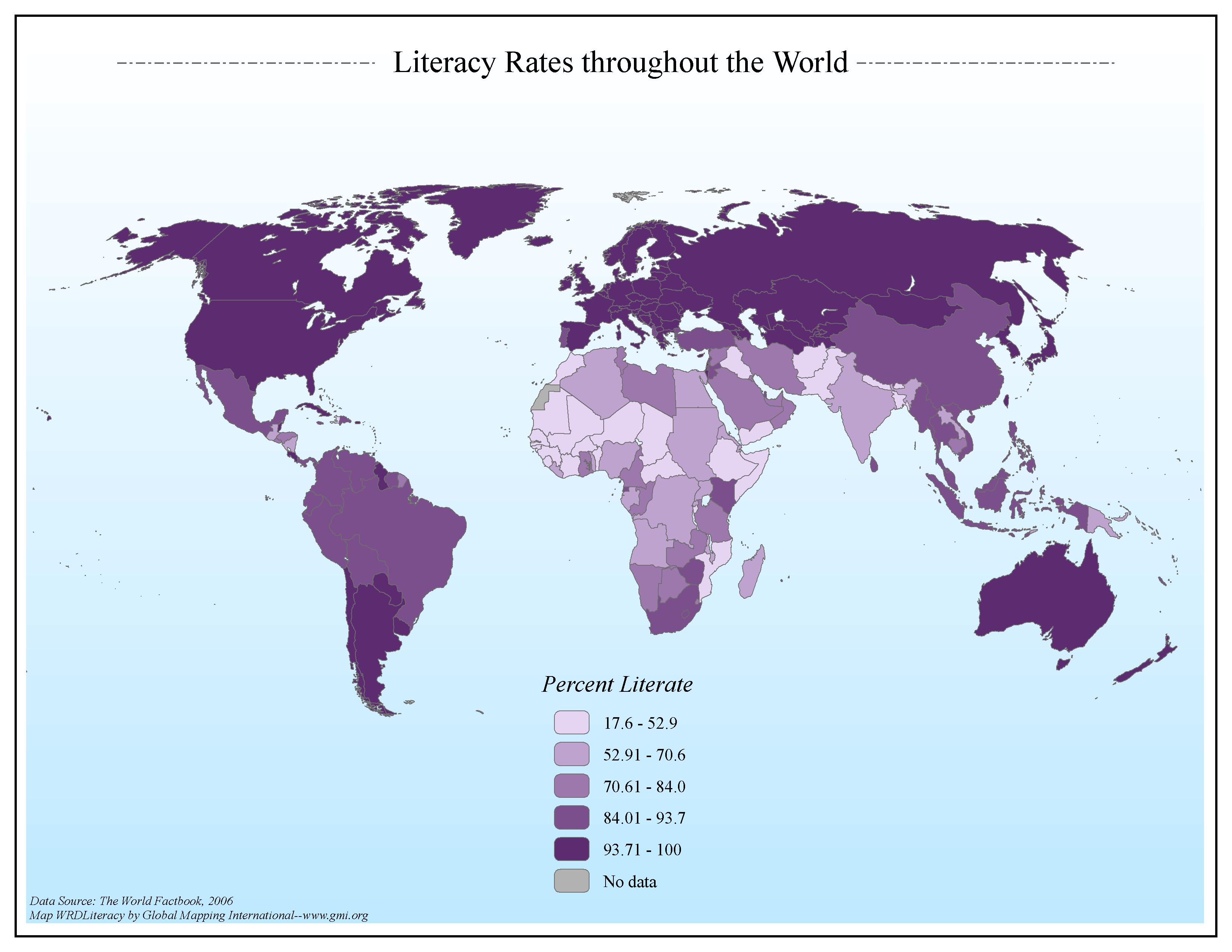
Literacy Rates throughout the World
·Type: Maps ·Map Date: 2006 ·Data Source: The World Factbook, 2006 ·Producer: Global Mapping International ·Collection: Factbook (GMMS 2007) ·Size: 8½ x 11 inches, landscape ·Categories: Type...

Lithuania
For a more detailed listing click here Lithuanian lands were united under MINDAUGAS in 1236; over the next century, through alliances and conquest, Lithuania extended its territory to include most of present-day Belarus and Ukraine. By the end of...

Lithuania (Joshua Project)
Progress Scale: Superficially Reached Population: 2,830,000 Capital: Vilnius % Professing Christian: 84.83 % Evangelical: 1.40 Peoples Count: 14 In 10/40 Window: N Region:...
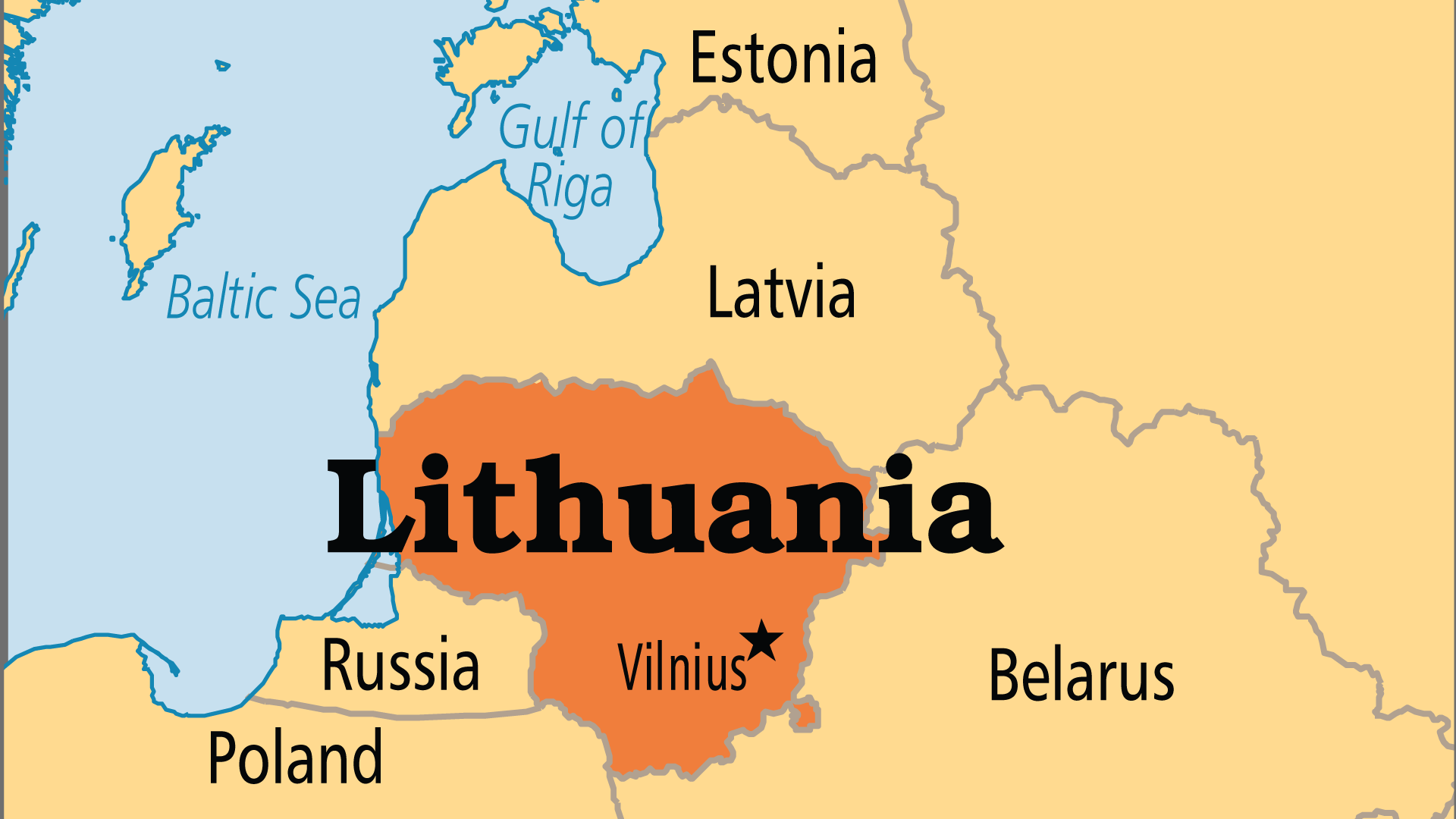
Lithuania (Operation World)
Largest Religion: Christian Number People Groups: 21 Number Languages: 12 Official Language: Lithuanian For more information go to Lithuania on the Operation World website. The above link opens in a new tab.

Lithuania (Prayercast)
Government: Semi-Presidential Republic Major People Groups: Lithuanian, Polish (Pole), Russian, Samogit (Lithuanian), Belorusian GDP Per Capita: $36,700 Literacy Rate: 99.8% Unreached:...
Lithuania (WorldBank)
NOTE: The most recent year's information is shown below. Click on the year to see all years for this indicator. COMMUNICATION2022 3,826,338 Mobile cellular subscriptions2022 88 Individuals using the...
Living Faith at Work for a Lifetime
Timo Plutschinski interviews Adel Azmi, Edna Mercado Ortiz, and Stephen Mbogo about how their faith has enabled them to navigate the complexities of the workplace. Their stories and examples, in both very difficult failures and successes, speak...
Living Faith at Work for a Lifetime
Timo Plutschinski interviews Adel Azmi, Edna Mercado Ortiz, and Stephen Mbogo about how their faith has enabled them to navigate the complexities of the workplace. Their stories and examples, in both very difficult failures and successes, speak...
Living in the Tensions of India
Pastor Paul Augustine describes how Indian Christians live out their faith in a society that is religiously pluralistic but also proud of being secular. He gives examples of ministry beyond the walls of the church as Christians live in this tension....
Local Leadership in Africa
Duncan Olumbe (Kenya) shares some of the issues and unique challenges in raising up local leaders in Africa. For more information go to https://lausanne.org/content/local-leaders-africa-case-study on the Lausanne Movement website. The above link...

