All Products
The Vision of the Lausanne Movement: Accelerating Global Mission Together
The Vision of the Lausanne Movement: Accelerating Global Mission Together From stirring historical stories to key challenges ahead, Michael paints a vivid picture of the Movement’s purpose and vision of uniting the global church in addressing the...
The Way Forward
Michael Oh expresses his thanks to the leaders of the Lausanne Movement and addresses the gathering as the movement’s new Executive Director and CEO. He poses the questions, ‘What will Lausanne look like in ten years? What will the world look...

The Way of St. James Series (Jesus Film)
Three friends hike the famous pilgrimage of Camino de Santiago in search of escape, meaning, rest, and adventure. This documentary style series of videos follows along as this group of friends navigate the Camino’s twists and turns and venture...
The Wealth of the Poor: Women and the Savings Movement in Africa
This paper explores biblical principles of wealth, poverty, and power in view of World Relief’s emerging Savings for Life economic development programs in the Great Lakes region of Africa. Principles: Wealth, Poverty, and PowerPractice: African...
The WEEK: Families Journeying Together Towards 2033
Welcome to TheWeek.life In the heart of every believer lies the story of Jesus Christ’s journey from Palm Sunday to Resurrection Sunday—a narrative that has the power to transform lives and communities. As we look ahead to 2033, marking 2000...
The Weekly Roundup (Justin Long)
275+ issues available For example oundup 275 contains: Top Events The war in Ethiopia could continue for months, or end in weeksXi’s China is closing to the worldSoutheast Asia is once again openingThe minichurch is the latest trend in...
The Whole Armor of God
Ramez Atallah identifies our true enemies and gives insight into how we can protect ourselves using God’s weapons rather than the world’s. Rebecca Atallah then witnesses to how God’s power overcame the forces of evil in an impoverished garbage...
The Whole Church as a Transformed and Transforming Society
When evangelicalism was defined at the international conference convened in London in 1846 to establish the Evangelical Alliance the definition explicitly excluded an ecclesiological statement. The reason for this was that the great evangelical...
The Whole Church taking the Whole Gospel to the Whole World
Part I – The Whole Gospel We began with “the whole gospel” because the church is itself the product and demonstration of the gospel – not merely its carrier. The gospel, as God’s good news in Jesus of Nazareth, is intimately tied to how we...
The Whole Church – A Brief Biblical Survey
I The Origin of the Church II The people of God in the Old Testament III The People of God in the New Testament IV Pictures of the Church For more information go to The Whole Church – A Brief Biblical Survey on the Lausanne Movement website. The...
The Whole World – Statement of the Lausanne Theology Working Group (Beirut 2010)
A. The World In The Bible B. The World of God’s Creation C. The World of Cultures and Religions D The World Of Sin And Redemption For more information go to The Whole World – Statement of the Lausanne Theology Working Group (Beirut 2010) on the...
The Willowbank Report: Consultation on Gospel and Culture
The process of communicating the gospel cannot be isolated from the human culture from which it comes, or from that in which it is to be proclaimed. This fact constituted one of the preoccupations of the Lausanne Congress on World Evangelization in...
The Work of God through Biblical Justice and Social Concern
How should the Church integrate evangelism and justice? Soong-Chan Rah explores the biblical foundation for justice as an essential part of the gospel. From the Old Testament prophets to Jesus’ teachings and the early Church, he demonstrates how...
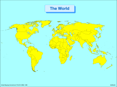
The World
·Type: Maps ·Description: Political World Map ·Map Date: 2002 ·Producer: Global Mapping International ·Collection: Regions (WorldVue 2002) ·Size: 8½ x 11 Inches, landscape ·Categories: Type ::...
The World (BW)
·Type: Maps ·Description: Political World Map ·Map Date: 2002 ·Producer: Global Mapping International ·Collection: Regions (WorldVue 2002) ·Size: 8½ x 11 Inches, landscape ·Categories: Type ::...
The World (Prayercast)
There are 7.2 billion people in the world today, and 2 billion have never heard the life-saving message of the gospel. When numbers reach into the billions, they seem to lose meaning; they are simply too big. However, if we shrink the world’s...
The World in the Bible
The idea of ‘gaining the whole world’ while ‘losing your own soul’ crossed my mind as I struggled to work through a concordance search on the biblical words translated ‘world’ and related words and concepts. It was a most illuminating...
The World Needs Servant Leaders
Paul Joshua (India) introduces three critical leadership issues involved in raising up local leaders for global missions, including the importance of community and servanthood. For more information go to The World Needs Servant Leader on the...
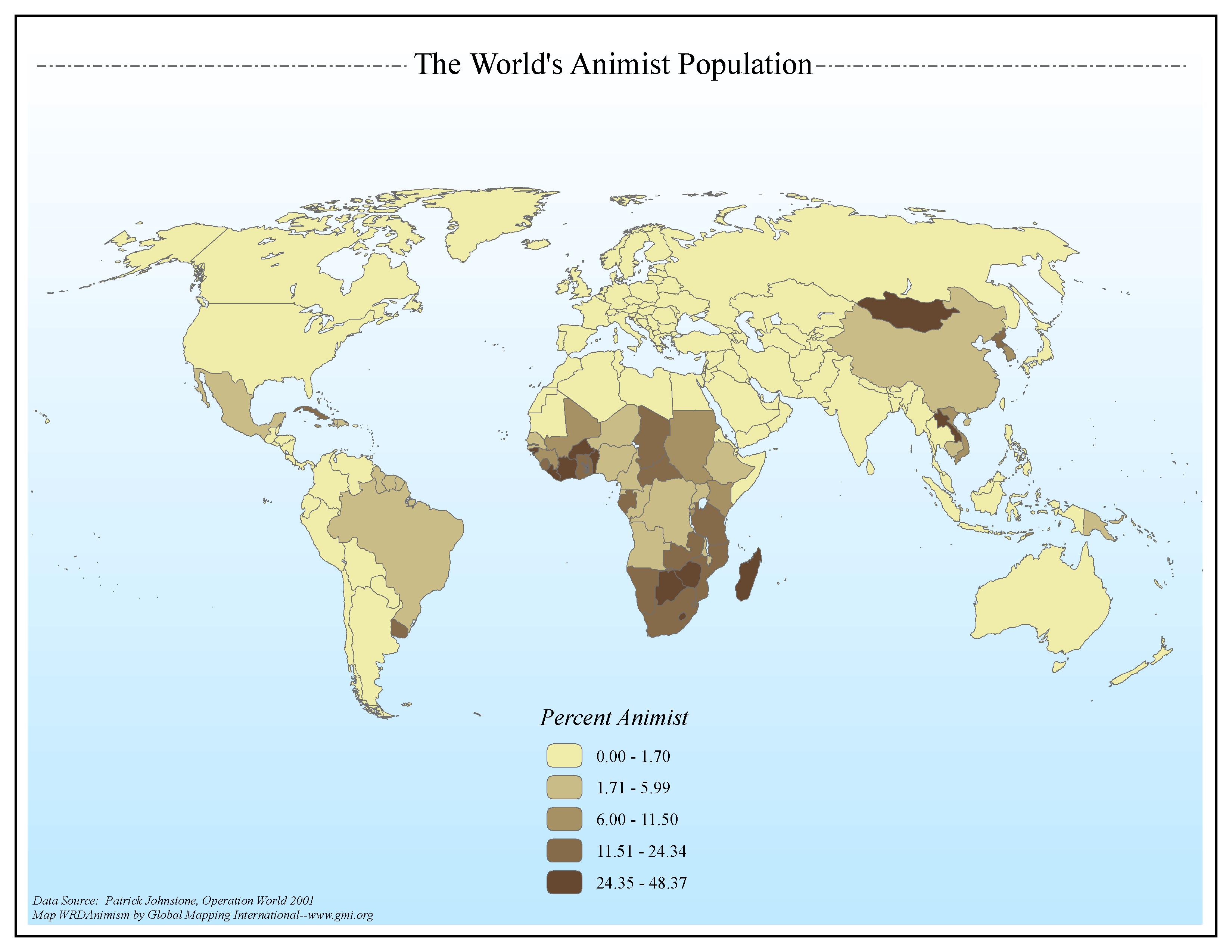
The World's Animist Population
·Type: Maps ·Map Date: 2006 ·Data Source: Patrick Johnstone, Operation World 2001 ·Producer: Global Mapping International ·Collection: General World Maps (GMMS 2007) ·Size: 8½ x 11 inches, landscape...
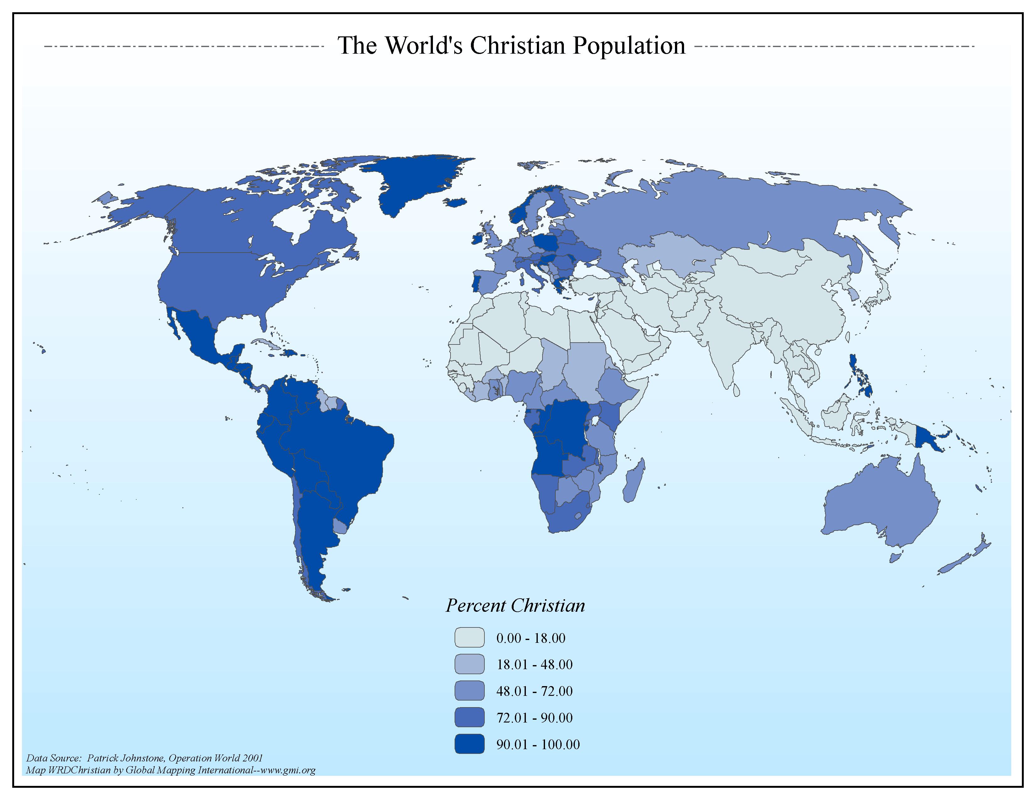
The World's Christian Population
·Type: Maps ·Map Date: 2006 ·Data Source: Patrick Johnstone, Operation World 2001 ·Producer: Global Mapping International ·Collection: General World Maps (GMMS 2007) ·Size: 8½ x 11 inches, landscape...
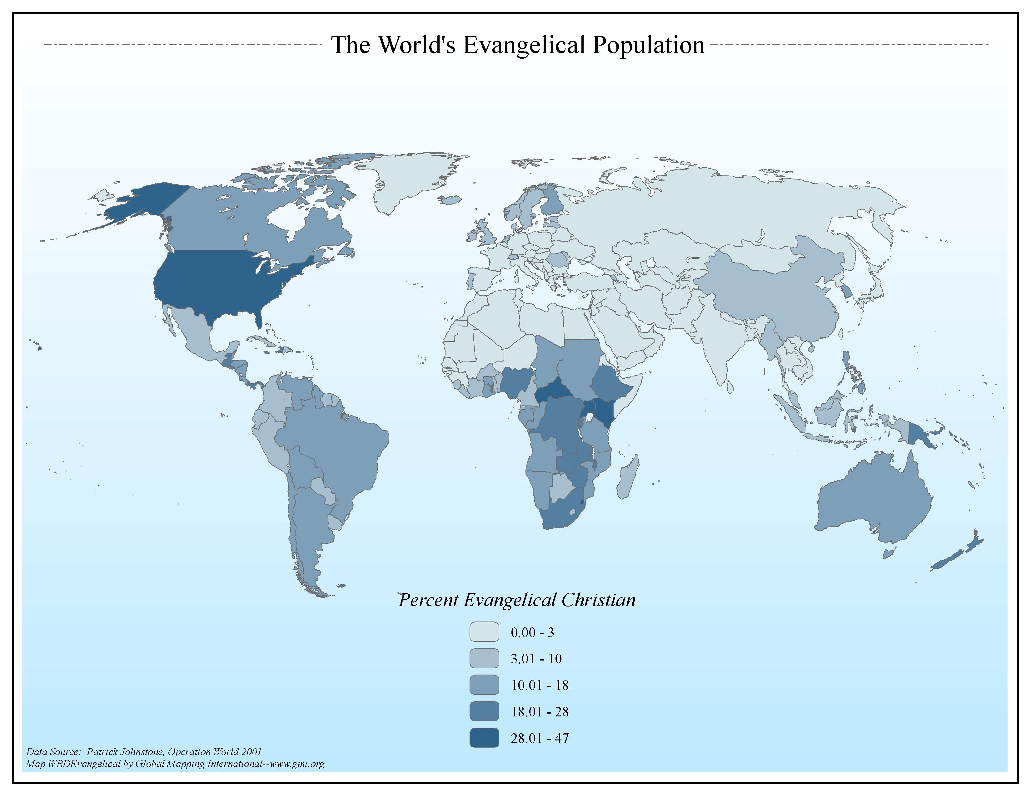
The World's Evangelical Population
·Type: Maps ·Map Date: 2006 ·Data Source: Patrick Johnstone, Operation World 2001 ·Producer: Global Mapping International ·Collection: Worldwide Perspectives GMMS 2007 ·Size: 8½ x 11 inches,...
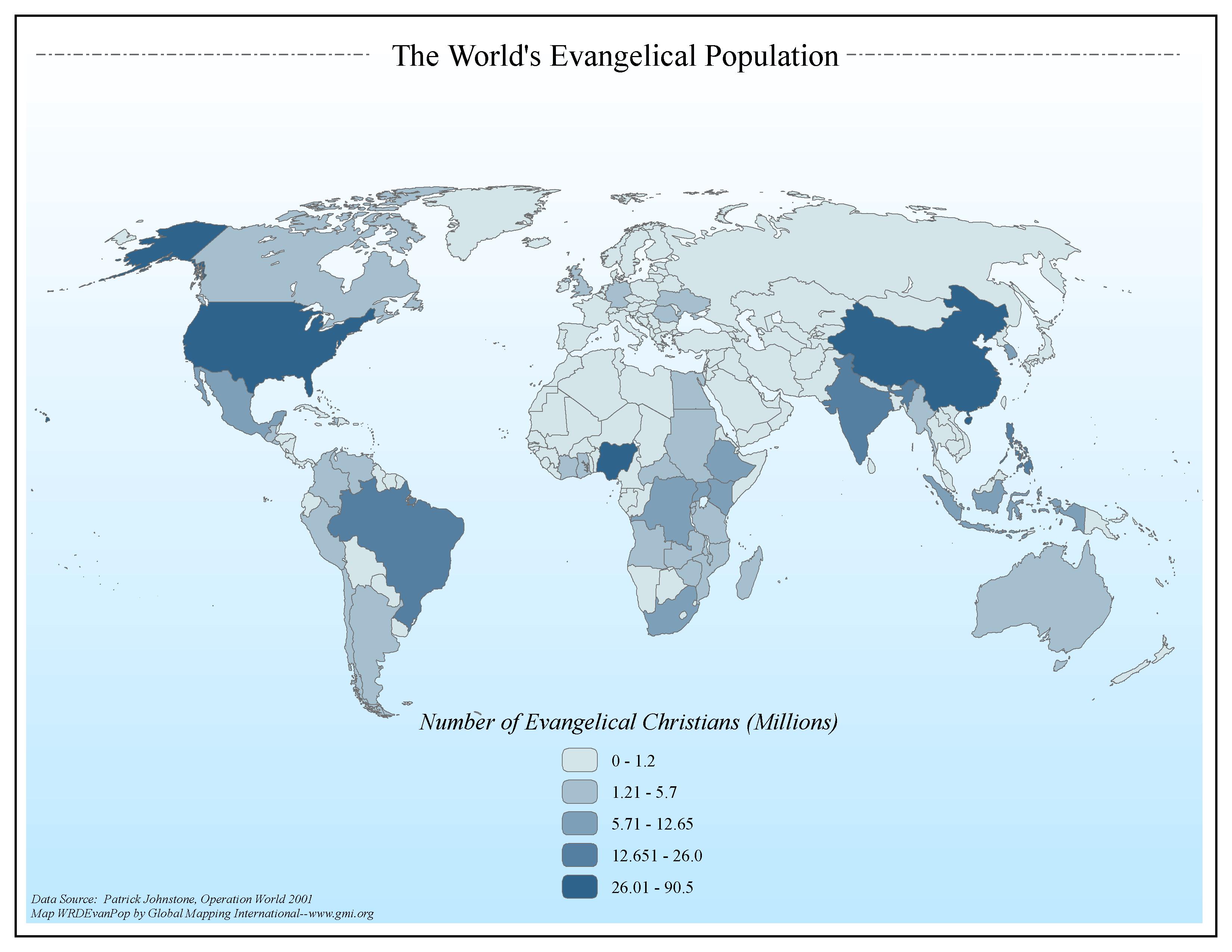
The World's Evangelical Population
·Type: Maps ·Map Date: 2006 ·Data Source: Patrick Johnstone, Operation World 2001 ·Producer: Global Mapping International ·Collection: General World Maps (GMMS 2007) ·Size: 8½ x 11 inches, landscape...
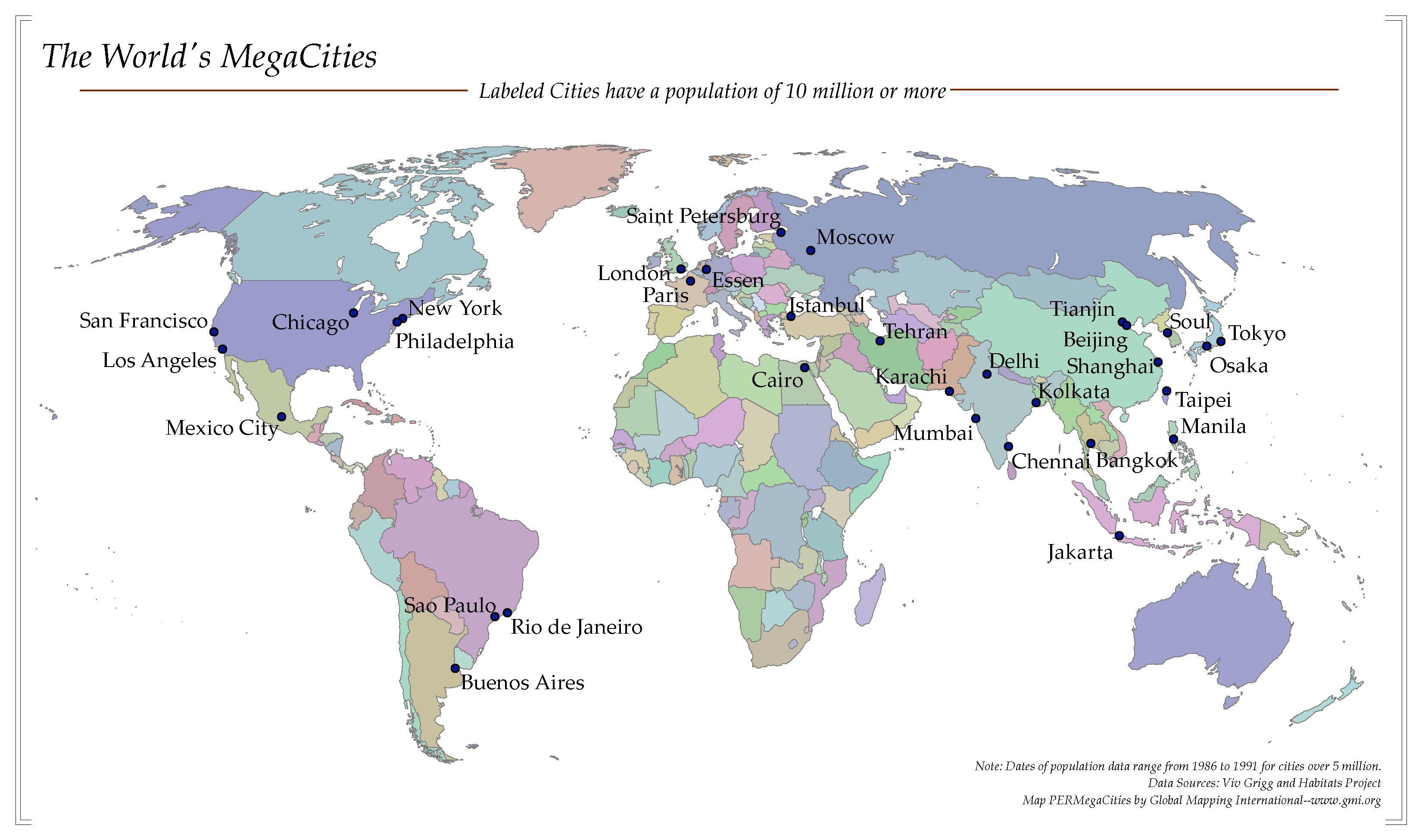
The World's MegaCities
·Type: Maps ·Map Date: 2006 ·Data Source: Viv Grigg and Habitats Project ·Producer: Global Mapping International ·Collection: Worldwide Perspectives GMMS 2007 ·Categories: Type :: Maps Continent/Region ::...
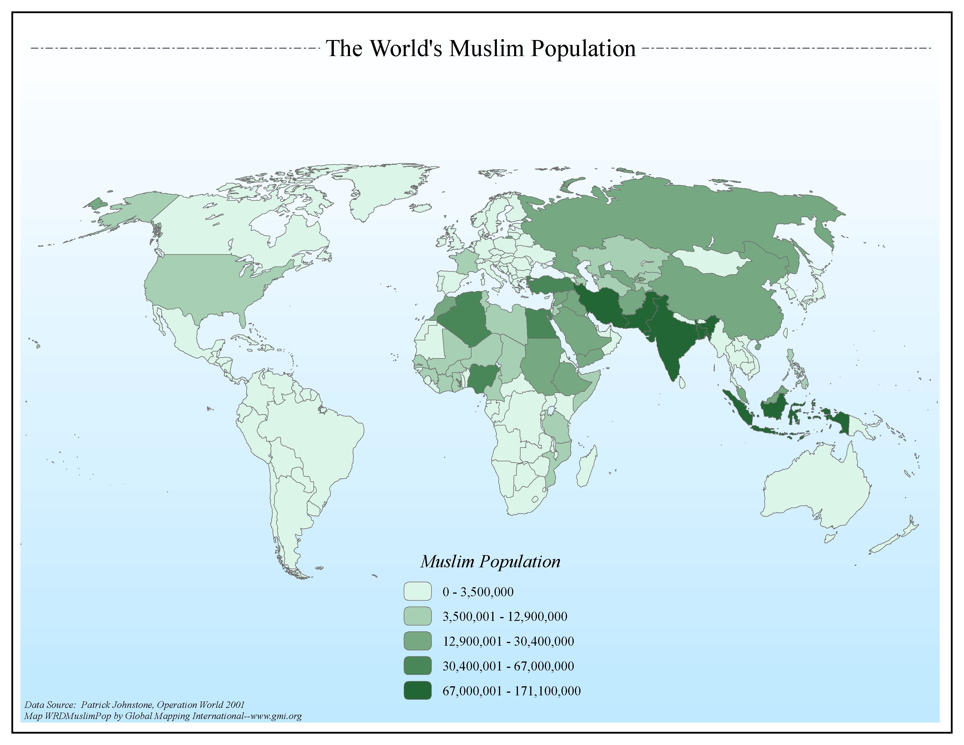
The World's Muslim Population
·Type: Maps ·Map Date: 2006 ·Data Source: Patrick Johnstone, Operation World 2001 ·Producer: Global Mapping International ·Collection: General World Maps (GMMS 2007) ·Size: 8½ x 11 inches, landscape...
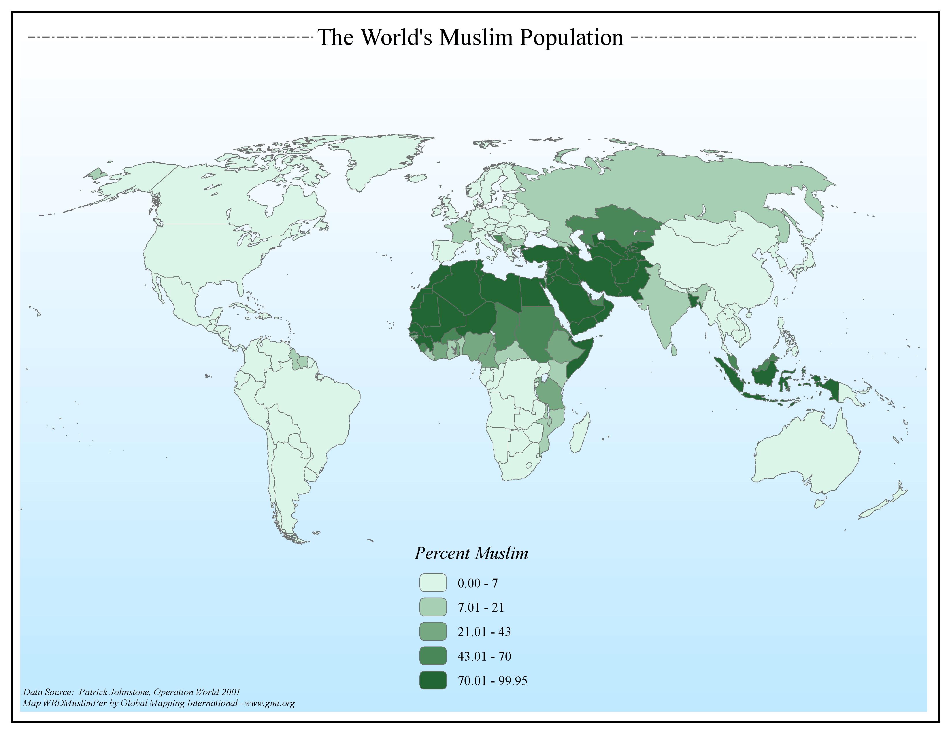
The World's Muslim Population (by percent)
·Type: Maps ·Map Date: 2006 ·Data Source: Patrick Johnstone, Operation World 2001 ·Producer: Global Mapping International ·Collection: The World of Islam (GMMS 2007) ·Size: 8½ x 11 inches, landscape...
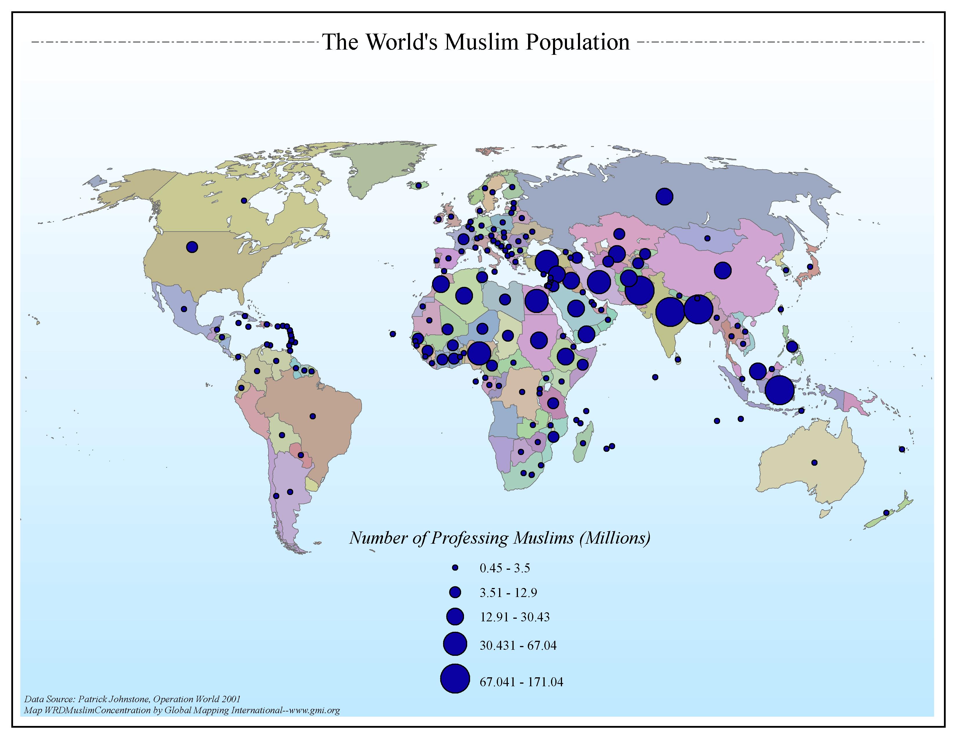
The World's Muslim Population (by population)
·Type: Maps ·Map Date: 2006 ·Data Source: Patrick Johnstone, Operation World 2001 ·Producer: Global Mapping International ·Collection: The World of Islam (GMMS 2007) ·Size: 8½ x 11 inches, landscape...
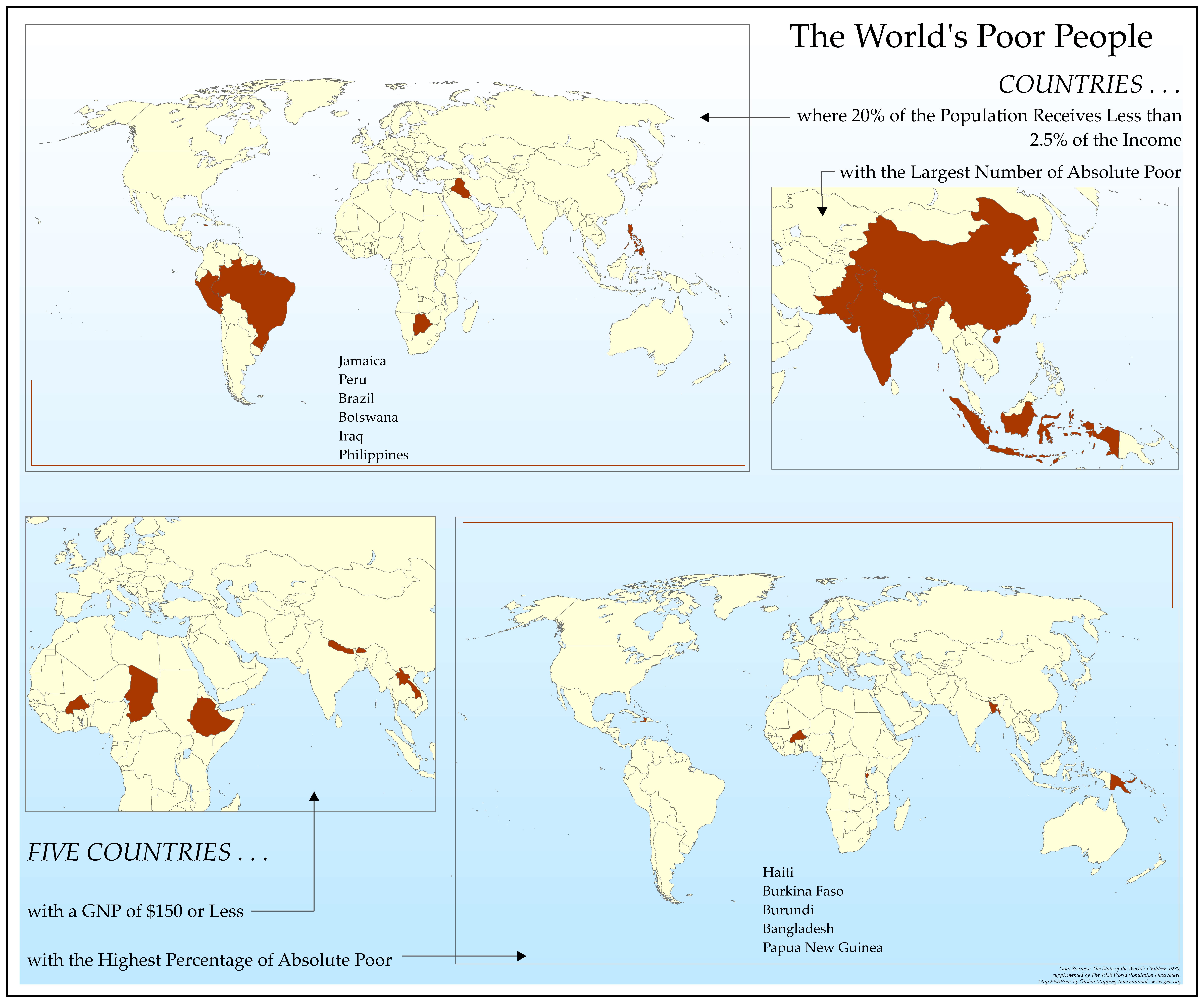
The World's Poor People
·Type: Maps ·Map Date: 2006 ·Data Source: The State of the World's Children 1989, supplemented by The 1988 World Population Data Sheet. ·Producer: Global Mapping International ·Collection: Worldwide Perspectives...
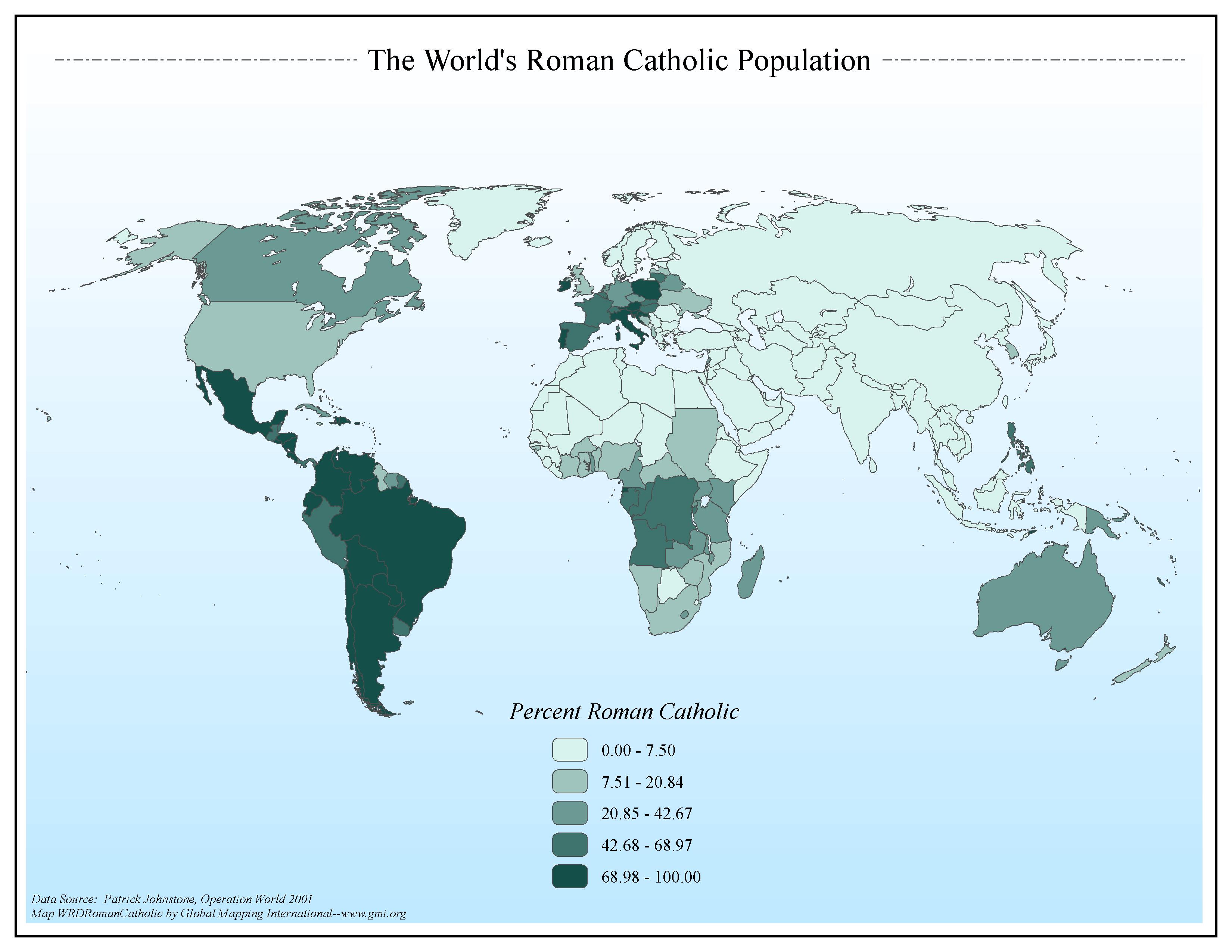
The World's Roman Catholic Population
·Type: Maps ·Map Date: 2006 ·Data Source: Patrick Johnstone, Operation World 2001 ·Producer: Global Mapping International ·Collection: General World Maps (GMMS 2007) ·Size: 8½ x 11 inches, landscape...
Theological Education in the Context of World Christianity
Dr Timothy Tennent, President of Asbury Theological Seminary, delivers the keynote address at the 2012 Lausanne Consultation on Global Theological Education, held at Gordon-Conwell Theological Seminary in South Hamilton, Massachusetts, USA, from 29...
Theology of the Body—A Conversation with Dr Timothy Tennent
In a time of rapid cultural shifts and increasing confusion about what it means to be human, the church was often perceived as lagging behind in responding to the deep questions surrounding human identity, embodiment, and the pursuit of health,...

